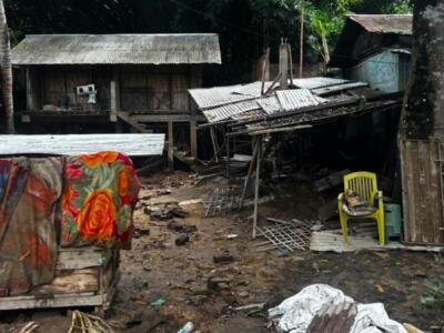






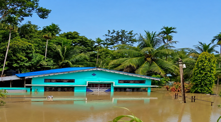
Guwahati — Floodwaters are slowly receding in Assam after weeks of devastating monsoon rains that have killed at least 68 people and displaced hundreds of thousands, but officials warn that the humanitarian and environmental crisis is far from over.
According to the Assam State Disaster Management Authority (ASDMA), 445,495 people remain affected across six districts, although the overall flood situation has improved slightly in recent days. No new deaths were reported in the latest official update.
The worst-hit districts are in Upper Assam, a region that has rarely witnessed flooding of this scale in recent decades. Authorities describe the disaster as one of the most severe to strike the area in nearly sixty years.
Sivasagar district has recorded the highest death toll, with 30 fatalities, followed by Charaideo with 20 and Jorhat with nine. Additional deaths have been reported from Dhemaji, Golaghat, Karbi Anglong and Sonitpur, while one person died during urban flooding.
Officials say most victims drowned or were swept away by rapidly rising floodwaters. Others were killed in landslides and the collapse of flood-damaged homes.
Upper Assam emerges as the epicentre
While Assam experiences seasonal flooding almost every year because of the Brahmaputra River and its tributaries, this year’s disaster has shifted towards districts that are generally less associated with catastrophic inundation.
Charaideo remains the worst-affected district, where 188,404 people continue to live with flood impacts. More than 144,000 residents are affected in Sivasagar, while nearly 75,000 people remain stranded in Jorhat.
Flooding has also affected parts of Golaghat, Nagaon and Kamrup Metropolitan, where heavy rainfall triggered urban flooding in several neighbourhoods.
Although water levels have begun falling along sections of the Brahmaputra, the Dhansiri (South) River near Numaligarh continues to flow above the danger level, keeping emergency services on alert.
Crops destroyed and livestock losses mount
Beyond the immediate loss of life, the floods have dealt a heavy blow to Assam’s rural economy.
More than 37,000 hectares (91,800 acres) of farmland remain submerged, much of it planted with seasonal paddy crops that support thousands of farming households. Local representatives have appealed for government compensation and financial assistance, warning that many families now face the loss of an entire growing season.
The livestock sector has also suffered extensive damage.
ASDMA estimates that 26,679 domestic animals, including cattle, goats, sheep and poultry, have died or been washed away by floodwaters.
Charaideo alone accounts for almost 10,000 livestock losses, making it the hardest-hit district for animal casualties.
Officials also warn that more than 882,000 surviving domestic animals face severe fodder shortages because grazing land remains underwater, raising concerns about further economic losses even after floodwaters recede.
Wildlife conservation setback
The flooding has also affected Assam’s internationally renowned wildlife.
In Kaziranga National Park, a UNESCO World Heritage Site famous for its endangered greater one-horned rhinoceros, forest authorities have reported the deaths of 137 wild animals, including six one-horned rhinos and several hog deer.
Every year, wildlife in Kaziranga migrates to higher ground during floods, but unusually rapid rises in water levels can leave many animals trapped.
Conservationists say such losses underline the growing challenge of protecting biodiversity as extreme weather events become more frequent.
Rescue effort continues
Relief operations remain underway across affected districts.
The state government says 90 relief camps are sheltering nearly 29,000 displaced people, while dozens of relief distribution centres continue supplying food, drinking water and essential items.
Teams from National Disaster Response Force (NDRF), the State Disaster Response Force (SDRF) and local emergency agencies are using rescue boats to reach isolated villages, evacuate stranded residents and deliver humanitarian assistance.
Veterinary teams have also established emergency treatment camps for surviving livestock in flood-affected areas.
Why were the floods so severe?
Meteorologists and state officials attribute the disaster to an exceptional combination of intense rainfall and the geography of India’s north-east.
Heavy rain fell not only across Assam but also in neighbouring hill regions, including Nagaland, where some areas recorded 137 millimetres (5.4 inches) of rainfall within eight hours. Water rushing down from the hills rapidly filled rivers across the plains.
Chief Minister Himanta Biswa Sarma has said several monitoring stations recorded rainfall between 435% and 490% above historical averages, causing rivers to rise faster than flood-control systems could manage.
Scientists have increasingly warned that climate change is making extreme rainfall events more intense across South Asia, while deforestation, encroachment on wetlands and rapid urbanisation can worsen flooding by reducing the landscape’s ability to absorb excess water.
For millions of people living along the Brahmaputra basin, seasonal flooding has long been a part of life. But experts say increasingly intense rainfall and changing weather patterns are making such disasters more destructive, placing greater pressure on communities, infrastructure and wildlife.
As waters gradually retreat, attention is shifting from rescue to recovery. For many families who have lost relatives, homes, crops and livestock, rebuilding livelihoods is expected to take months, while the longer-term challenge of adapting to more frequent extreme weather is likely to remain at the centre of policy debates in one of India’s most flood-prone states.